Evolution of Road Networks
March 20, 2012
My
elementary school was just a short distance from my home, so I walked and I didn't take a
bus. One street corner on the path from home to school had the usual
orthogonal intersection of streets and
sidewalks; but the house on that corner had a small
lawn on a
front yard. We students never kept to the sidewalks at that corner; instead, we made a
diagonal path across the lawn. Our constant traveling made a dirt path through the
grass, but the homeowner was too kind to
make an issue of this.
One
university that I attended had a huge
quadrangle; that is, a large, open grassy space around which many of the university buildings had been built. The "quad," as it was called, was criss-crossed with sidewalks. The students, however, were smarter than the
landscape designers, since they made their own well-worn paths through the grass in the places where the sidewalks should have been.
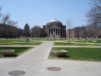
Photograph of the Syracuse University Quad
(April 19, 2005).
The yellow tape was part of a project, and it was not placed to keep students off the grass.
Via Wikimedia Commons)
Now, with ubiquitous
computing, it would be very easy to let an
ant colony algorithm loose on any landscape to mark the optimal locations of sidewalks. The input of such a computer simulation would be the number of trips required between building pairs. Things would be nice for a few years, but then the buildings would be repurposed, new building would be constructed, and we're back to the dirt paths.
As all
suburb-dwellers know, the improvement of
highways to their areas helps to lessen
automobile traffic for just a few years. After that, there's an influx of new vehicles from people who have used these improved roads as an enabler for building homes in more distant suburbs. Those distant suburbs, which had just a few roadways in the past, are then covered with a
network of new roads.
This creep in
urbanization is a worldwide phenomenon. The percentage of the
world population living in urban areas is now more than fifty percent.[1] This is in stark contrast to 1800, where only three percent lived in urban areas, and the percentage is still rising. Thirty percent lived in urban areas in 1950, and it's estimated that sixty percent will live there in 2030.[1-2] This urbanization process is evident, but are there any rules to the process that could help with urban planning?
A recent paper by a large, multinational team of
scientists reports on the
evolution of road networks.[3] The research team studied the evolution of roads over the last 200 years in Groane, an area north of
Milan, Italy. This area was especially well suited for study, since its fragmented
municipal base prevented any overall large-scale planning. Groane, which has 29 urban centers within 14 municipalities, covers 125
square kilometers. Its evolution has been along two
radial paths to nearby
Como and
Varese. The path to Como dates back to the
second century BC, and the path to Varese dates to the
sixteenth century.[3]
The study identified four distinct phases of the urbanization of this area.[3]
i) Rural phase (1800-1918): A pre-industrial, agricultural economy, with no major roads.
ii) Early-urban phase (1918-1945): A mostly agriculture economy, with the first appearance of rail network, small industrial parks, and some expansion of rural settlement around the central area.
iii) Urban-industrial phase (1945-1990): Residential and industrial sprawl, with population growth and highway construction.
iv) Metropolitan post-industrial phase (1990- 2012): Decline of industry, a slower urban sprawl, and increased long-range mobility of the population due to high speed trains and large highway systems.
The development of roads was found to proceed by these two elementary processes, as shown in the figure.[3]
(i) Densification, an increase in the local density of roads around existing urban centers.
(ii) Exploration, in which new roads trigger the spatial evolution of an "urbanization front."
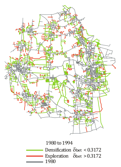
The evolution of roads in the Groane, Italy, region.
Shown is the baseline, 1800, road network (blue), and the densification (green) and exploration phases (red).
Figure 5b of reference 3, via the arXiv Preprint Server. [3)]
These processes result in an evolution of the road network characterized by a build-out of shorter roads as time goes on (see figure). Local roads of the densification phase and exploratory roads are shorter than the baseline roads that were built to connect the first populated areas.
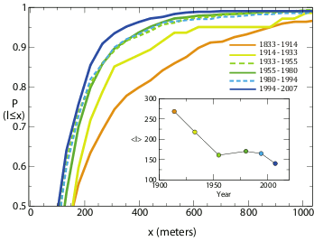
New roads are shorter as time goes on.
After an initial build-out of long roads, shorter local roads (densification) and exploratory roads take precedence.
Fig. 4 of ref. 3, via the arXiv Preprint Server. [3)]
References:
- Human Population: Urbanization, Population Reference Bureau.
- World Population Highlights 2007: Urbanization, Human Population: Urbanization, Population Reference Bureau.
- Emanuele Strano, Vincenzo Nicosia, Vito Latora, Sergio Porta and Marc Barthelemy, "Elementary processes governing the evolution of road networks." arXiv Preprint Server, March 1, 2012
Permanent Link to this article
Linked Keywords: Elementary school; school bus; orthogonal; sidewalk; lawn; front yard; diagonal path; grass; You kids get off my lawn!; university; quadrangle; landscape design; Syracuse University; Wikimedia Commons; computing; ant colony algorithm; suburb; suburb-dwellers; suburbanite; ; highway; automobile; traffic; network; urbanization; world population; scientist; evolution; Milan, Italy; municipality; square kilometer; radial path; Como; Varese; second century BC; sixteenth century; industry; agriculture; economy; railroad; rail network; industrial park; metropolis; metropolitan; high-speed rail; high speed train; Interstate Highway System; highway system; arXiv.