Quo Vadis?
May 30, 2012
The title of this article, "
Quo vadis?," is
Latin for "Where are you going?" Aside from the
philosophical implications of this simple phrase, there's the practical matter that every day we take multiple journeys to places such as work, school, and food markets. Our local routes are
imprinted on our memories to the extent that we often drive on "
autopilot," not really thinking about the process that brings us from point "A" to point "B."
When I was younger,
gasoline was much less expensive, and there was considerable
competition among vendors. Most
intelligent people realized that there was no real difference between one
brand of gasoline and another, so the
service stations would give you free items, generally when you filled your
fuel tank. There would be
beverage glasses,
plastic toys, and volumes of
children's encyclopedias. There were also
road maps.
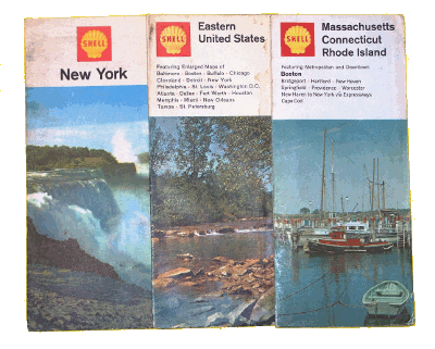
It's amazing what you find in the glove compartment of the family car.
These Shell Oil Company maps date from the late 1960s.
(Photo by author)
About a decade ago, everyone needed a
map if they were traveling a distance from their home, through places they had never been before, to an unfamiliar destination. Today, we have the ubiquitous
Global Positioning System (GPS), a much more important
spin-off of space technology than
space food sticks.[1]
The essential principle of GPS is so simple that even a
high school geometer can grasp it.
GPS satellites transmit
radio messages that indicate their position and the time that the messages were sent. This defines a
sphere whose
radius is the
speed of light multiplied by the transit time from the satellite to a
receiver.
The spheres of two satellites will intersect in a
circle, and the sphere of a third satellite will define two
points on the circle. One point will be wildly inaccurate, and the other will define the position of the receiver. This procedure is called
trilateration.
Since the speed of light is so large, even small timing
errors will produce a large position error, so this process is usually done with one, or more, additional satellites in the mix. In a
recent article (Baking Powder's Harvard Pedigree, May 1, 2012), I mentioned my opinion that
taxpayer dollars allocated to the
US Food and Drug Administration (FDA) was money well spent. This observation applies also to the GPS satellite system, which is operated by the
US Government as a
public service.
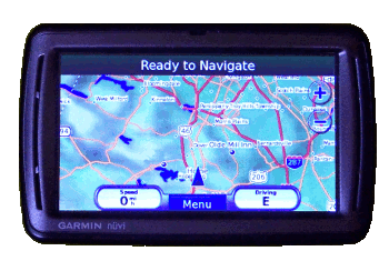
My personal GPS, a Garmin Nüvi, received as a gift from my daughter and her husband.
(Photo by author)
The present
accuracy of consumer GPS receivers, such as the one shown above, is about twenty
meters, but there are so-called
augmentation systems, particularly
FAA WASS, that bring the accuracy below a meter.
GPS was originally released for public use with 100 meter accuracy, a mode called "
Selective Availability" (SA); but SA was removed on May 1, 2000. At that time, many users were using additional ground-based transmitters in a method called
differential GPS to increase accuracy, so the decision was moot. This is how WASS and similar augmentation systems work. However, turning off SA was an aid for positioning on low cost receivers.
Many mobile devices, such as
cellphones, now incorporate GPS, which leads to many new applications, and new
privacy concerns. Such technology helps when you're looking for the nearest
pizza, but it might be a problem if a stalker is looking for you. Sometimes the stalker is one of the many persistent
marketers and
advertisers.
An example is shown by a recent
General Motors patent application, "Method Of Advertising To A Targeted Vehicle."[2-4] As its name indicates, it's a method to display
billboard ads to a particular vehicle. Although GM's present
OnStar system does not track vehicles, we might find a future in which such a system finds that you've been driving for several hours, surmises you need a break, and flashes a billboard ad for a restaurant targeted at you.
The restaurant is selected based on your past eating habits, as determined by the locations of other restaurants at which you've stopped; and this is a "
click-through" billing for the restaurant, since it's verified that you actually did stop there. You get a meal, and someone gets paid a dollar, or two.
Although some sensitive GPS receivers will work inside buildings, they aren't very useful, except to indicate that you are inside a building. One complaint I have about the "
anchor stores" in
shopping malls is that they try very hard to
camouflage their exits that lead to the mall, itself. They would rather you spend your money with them. That's when I could use an indoor GPS with a map of the mall.
Researchers at the
Fraunhofer Institute for Manufacturing Engineering and Automation IPA (
Stuttgart, Germany) have collaborated with several industrial partners to produce an indoor GPS-like system. I've mentioned
Fraunhofer research in a number of previous articles.[6]
This positioning system does not rely on radio signals, but on
dead-reckoning, in which speed and direction are determined by an
electronic compass and
accelerometers. It uses a
USB device that plugs into a
tablet computer or other devices, such as
smartphones (see photograph).[7]
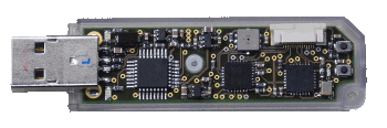
Fraunhofer navigation sensor for interior spaces.
(Copyright 2012, Fraunhofer-Gesellschaft))
To operate, a resident
application program downloads a three-dimensional building plan from the
Internet. This could be accomplished by reading a
QR coded plaque that would also set the initial position. The Fraunhofer team demonstrated this device at the
Sensor+Test trade fair in
Nuremberg, Germany, May 22-24, 2012.[7]
References:
- Space Food Sticks TV Commercial, YouTube video.
- GPS Accuracy, GPS.gov web site.
- Steven C. Tengler, Mark S. Frye and Timothy R. Nixon, "Method Of Advertising To A Targeted Vehicle," US Patent Application 20120054028, March 1, 2012.
- Keith Barry, "OnStar Files Patents for Minority Report-Style Billboards," Wired News, May 15, 2012.
- Ray Wert, "GM Files Patent To Make Minority Report Billboards A Reality," Jalopnik, April 30, 2012.
- Previous articles mentioning Fraunhofer research include Electric Vehicle Radio, April 11, 2012, Bridging the Last Mile, March 2, 2012, Working with Whey, January 18, 2012, Open Office, January 5, 2012, Free-Space Optical Communications, August 18, 2011, Chip Fingerprinting, February 28, 2011, and Scratching Diamond, December 6, 2010.
- Navigating the shopping center, Fraunhofer-Gesellschaft Press Release, May 3, 2012.
Permanent Link to this article
Linked Keywords: Quo vadis?; Latin; philosophy; philosophical; imprinting; imprinted; autopilot; gasoline; competition; intelligence; intelligent; brand; filling station; service station; fuel tank; beverage glass; plastic; toy; child; children; encyclopedia; road map; glove compartment; Shell Oil Company; map; Global Positioning System; GPS; NASA spin-off; spin-off of space technology; space food stick; high school; geometer; GPS satellite; radio; sphere; radius; speed of light; receiver; circle; point; trilateration; errors and residuals in statistics; taxpayer dollars; US Food and Drug Administration; US Government; public service; Garmin; accuracy; meter; augmentation system; FAA; WASS; Selective Availability; differential GPS; cellphone; privacy; pizza; marketing; marketer; advertising; advertiser; General Motors; patent application; billboard ad; OnStar; click-through; anchor store; shopping mall; camouflage; research; researchers; Fraunhofer Institute for Manufacturing Engineering and Automation IPA; Stuttgart, Germany; Fraunhofer; dead-reckoning; magnetometer; electronic compass; accelerometer; Universal Serial Bus; USB; tablet computer; smartphone; Fraunhofer-Gesellschaft; application software; application program; InternetvQR code; Sensor+Test trade fair; Nuremberg, Germany; US Patent Application 20120054028.